423959
- Title`Sketches. 1822. Van Diemen's Land', 1822-1847 / drawn by Thomas Scott
- Creator
- Call numberPXB 216
- Level of descriptionseries
- Date
1822-1847 - Type of material
- Reference code423959
- Issue CopyDigitised
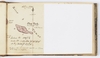
- Physical DescriptionApproximately 132 drawings (in 1 album, 100 pages) - pencil & watercolour - 11.2 x 19 x 2.2 cm
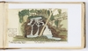
- Scope and Content1. Upper fall on / Jones's River / 1823. / South bank of the / River Derwent / V.D. Land [i.e Van Diemens Land] / T. Scott
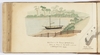
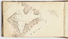
2. Green Island near to Blackman's Bay / When surveying the East Coast October 1822 / Taken in a whale boat coming out of / Frederick Hedrick's Bay E. Coast V.D.L / T. Scott
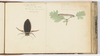
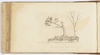
3. Lower fall on / Jones's River / 1823 / South bank of the / River Derwent / V.D. Land. / The land around it the property of / Walter Angus Bethune Esqr. / Gum tree - notched by the Natives with a flint stone / for climbing it. [sketch of tree on reverse]
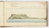
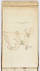
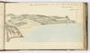
4. View of Maria Id. [i.e. island] from the Mouth of the Landspit [or Sandspit] River / When Surveying the East Coast of V.D. Land. Octr. 1822 / T. Scott [with key]
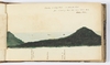
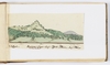
5. V.D. Land - Handsome Sugar Loaf - York Plains - Augt. 1821 - / bearing South
6. East View from Greenstone Bay Oct. 1822 / When surveying the East Coast / T. Scott.
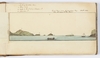
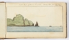
7. North Head in the East Bay on Maria Island / When out Surveying the E. Coast of V.D. Land 23 Oct. 1822 T.S.
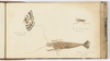
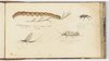
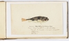
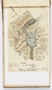
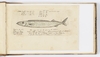
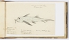
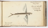
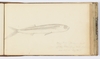
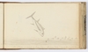
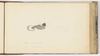
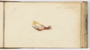
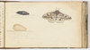
8. Poisonous Toad Fish of Van Diemens Land. / Caught in Muddy Creek, River Tasman 6th Novr. 1833. / Drawn from the living fish - as swimming in a basin of water [with measurements]
9. Maria Id. From N.E. head of Profsers [i.e. Prossers] Bay / Tuesday 22nd Octr. / 1822 / T.S. [with key]
10. Sketch - / on the 31st March / 1833 / Made in wading across the river below / the basin, at the outlet
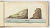
11. South Point of Maria Id. at Sea (bearing East from the Boats) / October 1822
12. Inside or West View of Rocks near Blackmans Bay on the East Coast of V.D. Land / October 1822 / T. Scott [with notes]
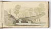
13. Sketch of the Huon River / in sailing up in a / Boat on a Voyage / of Discovery / 1st May 1829
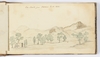
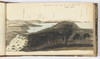
14. Oyster Bay from or round Mount at the upper end of St Pauls Plains - 1823. / (afterwards went to the top of the same mount with Col: Arthur / who named this "Mount Henry" after Capt. Lockyer of the 3rd Regt. / who accompanied us - in 1825 when after the Bushranger Brady &c.)
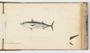
15. Lake Echo from the North. 1823 - When it was first discovered & named by us. / T.S. [with campsite]
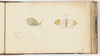
16. ["Jack fish" or "Sea Pike", 1833, with notes on weight, dimensions, colour, and place where caught]
17. Ben Lomond from Fletchers Hutt 1823
18a. "Waterfall" - On River Shannon, about two miles above Mr Patterson's House July 1825 / T. Scott
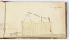
18b. Bearings taken from the top of Jacob's Sugar Loaf [list of places, compass positions, and distances]
19. Blowhole S. of Brown's River in the Derwent / Sketch by W.R. Neill 1823
20. Sketch of / Crescent Shore &c. / taken from / Mr Coulson's house / 27th June / 1833 / at low Water / showing all the Mud banks / &c. as they appear when dry
21a. Tent and encampment at Holmes's Hutt / Near Springhill River Clyde / T. Scott / 1823 / Carrotts Tom Kearney
21b-22. Launceston V.D.L. 1823
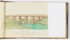
23. Bridge over the Elizabeth River at Campbelltown from the West / 3rd Novr. 1823 / T. Scott
24. A Fish Caught in the River Tamar / 5th March 1834 [with notes on dimension and colour]
25. Sketch of a Tyger [i.e. tiger] Trap. / intended for Mount Morriston. / 1823
26. Barnes's Bay / on the North part of / Bruni Island / Taken on the 24th Septr. / 1826 / by T. Scott
27. Main-land of Van Diemen's Land / Septr. 1826
28-30a. View from top of Mount Royal Signal Station, 1826. No.1, No.2, & No.3 [with geographical features marked]
30b. February 21st 1833 / Sketch of Pig Id. [with notes]
30c. Sketch from top of Mount Royal / Septr. 1826
31. [Shag Rock in River Tamar. Map] 10th Feby 1835
32. Sketch of part of Bruni Island / taken from top of / Mt Royal / Septr. 1826
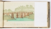
33. Deloraine 18th January 1832 / Bridge over the Meander from the East looking up and down the main
34. River Huon [and] Port des Cygnes
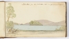
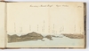
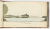
35. East view from the S. side of the Entrance into / South Port / in Septr. 1826
36. Deloraine - 18th January 1832 - / Bridge over the Meander bearing East looking down the river
37. Island near Coal Cliff leaving west 1/2 mile from land ... / Octr. 1826
38. Coal Cliff and S.E. point of S. Cape Bay form top of land [hill?] at mouth of Creek / Octr. 1826
39. Sketch taken from Mr McKee appn [i.e. application] for a / grant of 1500 acres to be located here / 7th Augt. 1833
40a. South Cape Bay / Delvett's [or DeWitt's] Islands over South Cape and the Mewstone / from the top Clear Hill above Whale Head / October 1826
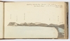
40b-41. Most Southern Snowy Mountains in Van Dieman's Land bearing North / from Clear Hill above Whale Head / October 1826
42. Sketch taken where / on a visit to Mr / [Gregson?] on the / morning of the 15th / July 1833 / on a walk before breakfast [Risdon Creek on the Derwent River]
43. Eddistone & Swilly Rock & Sidmouth Rock / from S. part of Clear Hill near Whale Head / October 1826
44. North East view from Clear Hill, near Whale Head / October 1826
45. Land selected by Captain McLeod of the "Brig Lion" [or Leon]
46a. Octr. 1826 / Sketch taken from the / top of the Clear Hill Wt of "Whale Head" - (taken in a great hurry)
46b. [North Bruni Island. Map]
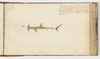
47. View of Cape Frederick Henry - taken from a Hill on the N. side of / Adventure Bay - / October 1826
48. South View of Adventure Bay - taken from a hill inside of / Cape Frederick Henry - at the N. end of Adventure Bay / October 1826
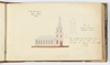
49a. St David's Church / Hobart Town / 1826 / From the / angle of Barrack / & Melville Streets - / The old spire has been pulled down / since this view was taken, and / something like the above erected in 1834.
49b. A porpoise / caught in the Derwent - / and a Sailor / one of the Boats / Crew / about / Decr. 1828 / Hobart Town - / by R. Neill
50. Hobart Town - from angle of Barrack & Melville Streets / and View of the River Derwent / 1826.
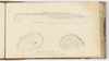
51a. 1826 - Bearings / From Rocky Pt opposite N. end of / Betsy Island [with notes]
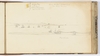
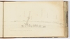
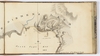
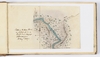
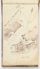
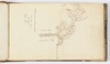
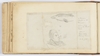
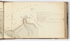
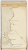
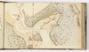
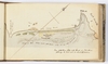
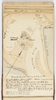
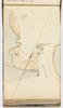
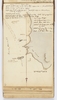
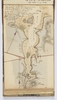
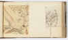
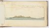
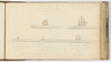
51b-56. [Maps of Bass Strait featuring Port Sorell, Badger Head, Port Dalymple, North East Bay, Port Frederick, featuring coastline, rivers, sand banks, islands, hills, and bearing notes and distances]
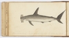
57a. Sketch of the Head / of the Navigation / of the River / Tamar / January 1833
57b. Head of Port Sorell
58. "Exocetus Volutans" / or / Flying Fish. / Flew on board the Ship / "Alexander Johnston" ... 30th May 1836 [with colour notes and dimensions]
59. Shoal of Porpoise's passing the ship "Alexr. Johnston" / on the 6th June 1836 ...
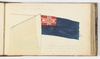
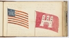
60. Since found on the 2nd July 1836 to be the / Flag of the "Kingdom of Sardinia" ...
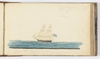
61. 9th June 1836 Brig Spoken ...
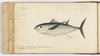
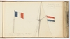
62a. An "Albecor" / caught in / ... / 11th June 1836 / See a plate at page 40 of Funnell's Voyage with Dampier 1707 / and a description at page 85
63a. "Side View" / Shovel nosed shark caught Sunday 12th June 1836 ...
64. Bruce's Novels [or Travels] Vol. 2nd page 230 Extract [notes]
65. View of the "Belly" of the / "Shovel nosed Shark" / or Hammer Headed Shark
66. From Cavier [notes on hammer head shark]
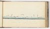
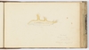
67. "Bonetta" [fish] / Caught Sunday 12th June 1836 [with dimensions and colour notes]
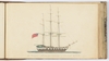
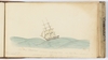
68. 11th June 1836 - Appearance of the "Shovel Headed" when in the water / following the ship [Grennock] ...
69. Flying Fish 8 inches in length / 15th June 1836 ...
70. An Albecor in pursuit of Flying Fish 15th June 1836 ...
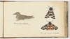
71. French and Dutch Flags, 20th & 24th June 1836
72. [Jelly fish] Caught along side in a calm / Monday 27th June 1836
73. Sea Snail / ... 27th June 1836 ...
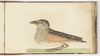
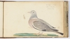
74. "Lepas" Barnacle 28th June 1838
75. [United States of American & City of Hamburg Flags]
76. View from Barque "Alexander Johnston" at 6 p.m. 4th July 1836 / in the North Atlantic Ocean ... [various ships]
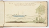
77. The Barque "Alexander Johnston" of Greenock ...
78. "Barnacle" with a shell growing on the ... 14th July 1836
79. the Brig "Spartan" (No. 5268) 20th July 1836 near Cape Clear Ireland ...
80a. A shrew Mouse caught near Earlston Berwickshire 13th July 1837 [with colour notes]
80b. From the Kelso Chronicle of June 22nd 1838 [notes on "Elephant-Hawk Moth".
81a. Remained all winter in this state, till the longest day / on the 22nd June 1838. When the butterfly cam out / of a dark purple inclining to brown / head / chrysalis / of the large Heather Grub ...
81b. Winter Chrysalis ...
81c. Moth came out of the Shell / on the 22nd June / Drawn on the 23rd June
82a. Gattonside Villa 14th May 1839 [moth]
82b. A butterfly found amongst the bushes in the Shrubbery / Drawn to the natural size
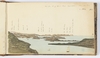
83. Wood Pidgeon or "Cushet" / Shot at E. [i.e. East] Morriston / 26th March 1840
84a. "A Water Beetle" / The Natural Size & colour / taken swimming in a basin of water / 12th May 1840
84b. "A Caterpillar" ... 15th May 1840
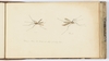
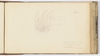
85a-b. Male [and] Female / Dragon Flies the Natural Size 7th July 1840.
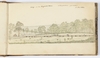
86a. A Wasp's Nest 11th July 1840
86b. Inside of the Comb with the Young Wasp
86c. Wasp. The Natural Size
87a. Moth ... 18th July 1840
87b. Fly ... 11th July 1840
87c. Shrimp The Natural Size / Porto Bello / 16th June 1841
88a. Island of [Loch or Inch?] Keith and Leith Roads / from Trinity Chain Pier
88b-89. View to the East and North from Porto Bello Sands
90a. Water-hen Earlston 15th Feby. 1842 / Caught at our front door Scraper by George
90b-c. Mouth Caught at Earlston 22nd July 1844
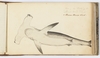
91a. The Hippocampus or Sea-Horse - River Derwent Van Diemen's Land
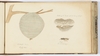
91b-c. The Haliatis - Ear Shell or / Mutton Fish of Van Diemens Land
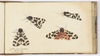
92a-d. Moth caught at Earlston / 19th July 1844 / The natural size
93a. A Heather Catterpillar [i.e. caterpillar] caught at Stabywood Hill July 1844
93b. Elephant Beetle / ... / 14 June 1845
93c. A Sort of May Fly / 18th June 1845
93d. A Water fly - a light brown colour / 14 June 1845
94. A Corn [Crack or Craik] / or "Land Rail" / 22nd June 1847 / about 1/2 size
95. South East door of Greenknow Tower 14th September 1836
96a. Crested Moth or Night Hawk / 28 June 1847 Earlston
96b. Barnards Creek - River Tamar 1833 / at 1/4 ebb tide / See page 431 Vol.1 of King's Voyages
97a. Wood-boat on the Tamar (Mr. Highetts boat) / lying on shore at low water on the mud / at Mr Bickford's Creek 1833
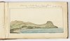
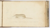
98a. South East Cape of Van Diemen's Land, 1826
98b. Bearings taken near the North of the largest Creek on the N.E. side of South Cape Bay - 1826 [notes]
99. Plan / of the city of / Kano / in Soudan / ...
100. East View of "Mona Vale" - The residence of Wm. Kermode Esqre / 28th January 1836 on Macquarie River. V.D. Land - Copying ConditionsOut of copyright: Creator died before 1955
Please acknowledge:: Mitchell Library, State Library of New South Wales - General note
The drawings in this album have been renumbered.
Some sketches have an additional drawing on the reverse and have been numbered a & b accordingly.
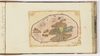
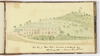
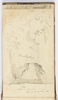
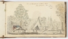
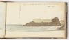
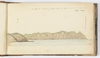
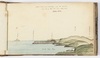
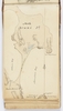
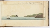
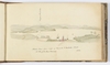
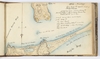
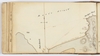
The sketches, some of which are signed and initialled, include maps, coastal profiles of Tasmania and adjoining islands made during exploring expeditions, as well as natural history drawings.
The sketches dated in 1836 were made on board the ship, 'Alexander Johnston'.
Two sketches are by R. Neill.
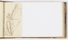
Some pages in the sketchbook are blank and some pages have multiple drawings on the one page.
19 drawings and 2 pages of text have been added into the sketchbook.
Some drawings in the sketchbook have a black rectangular border.
No.8 is loose in volume.
No.24 was drawn upside-down.
No.25 Sketch of a Tyger Trap (formerly numbered No.23) is reproduced in Von Stieglitz, K.R. (ed.) Sketches in early Van Diemen's Land by Thomas Scott. Hobart: Fullers Bookshop, 1966. (ML 986/29 A1)
"D.S. Mitchell" signature on front endpaper.
Digital order no:Album ID : 824042 - Signatures / Inscriptions
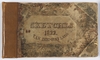
Titled from plate on front cover.
Inscribed on front endboard, "T. Scott / 1822 / Van Diemens Land -".
Some drawings are signed in pencil, "T. Scott" or initialled "T.S."
Drawings are titled and most are dated. - Name
- Subject
- Topic
- Place
- Exhibited in
A Rage for Curiosity - State Library of New South Wales (1 September, 1997 - 11 January, 1998)
View Media Files
2. 
3. 
4. 
5. 
6. 
7. 
8. 
9. 
10. 
11. 
12. 
13. 
14. 
15. 
16. 
17. 
18. 
19. 
20. 
21. 
22. 
23. 
24. 
25. 
26. 
27. 
28. 
29. 
30. 
31. 
32. 
33. 
34. 
35. 
36. 
37. 
38. 
39. 
40. 
41. 
42. 
43. 
44. 
45. 
46. 
47. 
48. 
49. 
50. 
51. 
52. 
53. 
54. 
55. 
56. 
57. 
58. 
59. 
60. 
61. 
62. 
63. 
64. 
65. 
66. 
67. 
68. 
69. 
70. 
71. 
72. 
73. 
74. 
75. 
76. 
77. 
78. 
79. 
80. 
81. 
82. 
83. 
84. 
85. 
86. 
87. 
88. 
89. 
90. 
91. 
92. 
93. 
94. 
95. 
96. 
97. 
98. 
99. 
100. 
101. 
102. 
103. 
104. 
105. 
106. 
107. 
108. 
109. 
110. 
111. 
112. 
113. 
114. 
115. 
116. 
117. 
118. 
119. 
120. 
- Browse collection hierarchy
- Manuscript Index
- A
- B
- C
- D
- E
- F
- G
- H
- I
- J
- K
- L
- M
- N
- O
- P
- Q
- R
- S
- T
- U
- V
- W
- X
- Y
- Z